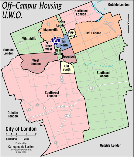
Maps
Off-Campus Designated Areas
Click on your desired area on the map to see Neighbourhood Boundaries & Descriptions.
TOP
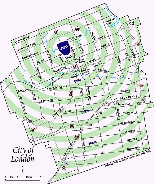
Distance to Western Campus
TOP
Neighbourhood Boundaries & Descriptions
Old North
- South of the North Thames River
- East of the North Thames River
- North of Oxford Street
- West of Adelaide Street
Neighbourhood Descriptions
- Borders the east side of UWO Main Campus & King’s University College.
- Housing types: Detached homes in residential areas & walk-up apartment buildings. Several high-rise apartment buildings in the 1200’s on Richmond St., north of the University Gates.
- Bus Routes running through this area (for more information on route schedules visit the London Transit website www.londontransit.ca): 1 Kipps Lane, 6 Richmond, 13 Wellington, 15 Huron Heights, 27 Capulet.
- Grocery shopping: Valu-Mart at Oxford St. & Richmond St.
- Banking: TD at the University gates on Richmond St.; CIBC at Oxford & Richmond St.
- Restaurants: Tasty Toasty, King Richie’s Pizzeria, and Omzzy’s Shawarma at the University gates on Richmond St.; The Bungalow at Cheapside St. & Waterloo St.; Palasad Social Bowl at Adelaide St. & Oxford St.
- Convenience store: B & C Variety at Richmond St. & Broughdale Ave.; Miles Variety Store at Richmond St. & Regent St.
- Health Care: Oxford Medical Walk-in Clinic at Talbot St. & Oxford St.; Urgent Care Centre (www.sjhc.london.on.ca/urgentcare) at St. Joseph’s Hospital located at Grosvenor St. & Richmond St.; Emergency Clinic at University Hospital is located in the north end of campus, off of Windermere Rd. & Western Rd. (On Campus)
- Recreation: Gibbons Park (bike & running trails, tennis courts, swimming pool & splash pad) with entrances at Sherwood Ave. & Victoria St., Grosvenor St. & St. George St. and Victoria St. and Gibbons Place; Ross Park (bike & running trail) with entrance at Richmond St. north of Raymond Ave.
TOP
Downtown
- South of Oxford Street
- East of the North Thames River & the Thames River
- North of the Thames River
- West of Adelaide Street
Neighbourhood Descriptions
- Housing types: Detached homes in residential area, apartments in walk-up complexes & high rises and townhouses.
- Bus Routes running through this area (for more information on route schedules visit the London Transit Commission web site www.londontransit.ca).
- High-density retail area throughout downtown includes: banking, groceries, shopping, night life, restaurants, Budweiser Gardens, Covent Garden Market, Museum London.
- Transit: VIA Rail Station (www.viarail.ca) located at York St. & Richmond St.
- Pharmacy: Shoppers Drug Mart located at Oxford St. & Adelaide St.; London Medical Pharmacy located on Dundas St. west of William St.; The Medicine Shoppe located at King St. & Colborne St.; Shoppers Drug Mart located at Richmond St. & Carling St.
- Health Care: Oxford Medical Walk-in Clinic at Talbot St. & Oxford St.; Emergency Clinic at University Hospital is located in the north end of campus, off of Windermere Rd. & Western Rd. (On Campus); Urgent Care Centre (www.sjhc.london.on.ca/urgentcare) at St. Joseph’s Hospital located at Grosvenor St. & Richmond St. (Old North)
- Recreation: Victoria Park main entrance located at Central Ave. & Richmond St.; Harris Park (running/biking trails) main entrance located at Ridout St. N. & Dufferin St.; Piccadilly Park (tennis courts & children’s play area) located at Waterloo St. & Kenneth Ave.
- London Public Library (www.londonpubliclibrary.ca) branch located in the Citi Plaza on Dundas St.
TOP
Near South
- South of UWO
- East of Platt’s Lane and Woodward Avenue
- North of the Thames River
- West of the North Thames River
Neighbourhood Descriptions
- Borders the south side of UWO campus
- Housing types: Detached homes in residential area, apartments in walk-up complexes and townhouses.
- Bus Routes running through this area (for more information on route schedules visit the London Transit website www.londontransit.ca): 2 Dundas, 9 Whitehills, 17 Oxford West, 20 Cherryhill. 33 Proudfoot.
- Grocery shopping: Metro at Cherryhill Mall at Oxford St. & Platt’s Ln.
- Convenience store: Hi-Ya Mini Mart at Western Rd. & Wharncliffe Rd. N.; 7-Eleven at Mt. Pleasant Ave. & Wharncliffe Rd. N.
- Restaurants: Alibi Roadhouse on Oxford St.; Blackfriars Bistro on Blackfriars St.; Several restaurants and fast food options at Oxford St. & Wharncliffe Rd. intersection.
- Health Care: Wharncliffe Walk-in Clinic (wharncliffewalkinclinic.com) located at Wharncliffe Rd. N. & Palmer St.; Emergency Clinic at University Hospital is located in the north end of campus, off of Windermere Rd. & Western Rd. (On Campus); Urgent Care Centre (www.sjhc.london.on.ca/urgentcare) at St. Joseph’s Hospital located at Grosvenor St. & Richmond St. (Old North)
- Recreation: Cavendish Park located at Cavendish Cres. & Walnut St.; Labatt Park located at Wilson Ave. & Riverside Dr.
TOP
Near West
- South of the Medway Creek
- East of Wonderland Road
- West of Western Road & Platt’s Lane
- North of the CPR Tracks
Neighbourhood Descriptions
- Borders the west side of UWO campus, as well as Huron University College & Brescia University College.
- Housing types: Detached homes in residential area, apartments in walk-up complexes, townhouses & high-rise apartment buildings.
- Bus Routes running through this area (for more information on route schedules visit the London Transit Commission web site www.londontransit.ca): 10 Wonderland, 9 Whitehills, 31 Hyde Park, 33 Proudfoot.
- Retail area at Sarnia Rd. & Western Rd. includes: fast food, convenience store & gas station.
- Pharmasave Western Plaza provides prescriptions, office supplies, textbooks, printing, copying and other services. (universitypharmacy.ca/locations/pharamasave-western-plaza).
- Health Care: Wharncliffe Walk-in Clinic (wharncliffewalkinclinic.com) located at Wharncliffe Rd. N. & Palmer St. (Near South); Emergency Clinic at University Hospital is located in the north end of campus, off of Windermere Rd. & Western Rd. (On Campus); Urgent Care Centre (www.sjhc.london.on.ca/urgentcare) at St. Joseph’s Hospital located at Grosvenor St. & Richmond St. (Old North)
- Recreation: Tennis courts located at Lawson Rd. & Wychwood Park; Park (basketball court, bike & running trail) with entrances off of Chesham Ave. & Castlegrove Blvd.; Medway Valley Forest (walking & biking trails) with entrances off of Wychwood Park & Doncaster Gate.
- Museum of Ontario Archaeology (archaeologymuseum.ca) located at Attawandaron Rd
TOP
Whitehills
- South of the City Limits
- East of the City Limits
- West of Wonderland Road
- North of the CPR Tracks
Neighbourhood Descriptions
- Housing types: Detached homes in residential area, apartments in walk-up complexes, townhouses and a few high-rise apartment buildings.
- Bus Routes running through this area (for more information on route schedules visit the London Transit Commission web site www.londontransit.ca): 9 Whitehills, 31 Hyde Park.
- Retail Area: Sherwood Forest Mall located on Wonderland Rd. includes groceries, banking, shopping, restaurants and fast food; Hyde Park Rd. & Fanshawe Park Rd. includes shopping, banking, fast food; Wonderland Rd. & Fanshawe Park Rd. includes groceries, shopping & fast food.
- Grocery shopping: Food Basics located at Sherwood Forest Mall on Wonderland Rd.; No Frills located at Wonderland Rd. & Fanshawe Park Rd.; Wal-Mart located at Hyde Park Rd. & Fanshawe Park Rd.; Unger’s Market on Gainsborough Rd.
- Bernies Bar & Grill (www.berniesbarandgrill.com) located in the Sherwood Forest Mall; Crossings Bar & Grill (www.crossingseatery.com) located on Hyde Park Rd.
- Pharmacy: Shoppers Drug Mart located at Wonderland Rd. & Fanshawe Park Rd. and Sherwood Forest Mall; Walmart Pharmacy located at Fanshawe Park Rd. & Hyde Park Rd.
- Health Care: Emergency Clinic at University Hospital is located in the north end of campus, off of Windermere Rd. & Western Rd. (On Campus); Urgent Care Centre (www.sjhc.london.on.ca/urgentcare) at St. Joseph’s Hospital located at Grosvenor St. & Richmond St. (Old North)
- Recreation: Park (children’s play area) with main entrance off of Aldersbrook Rd.; Park (baseball diamond, soccer field & children’s play area) with main entrance off of Aldersbrook Rd.
- London Public Library (www.londonpubliclibrary.ca) branch located in Sherwood Forest Mall on Wonderland Rd.
TOP
Masonville
- South of the City Limits
- East of the Medway Creek
- West of a line drawn between where Angus Road crosses Windermere Road and where Hastings Drive crosses Fanshawe Park Road
- North of the Medway Creek
Neighbourhood Descriptions
- Borders the north side of UWO main campus.
- Housing types: townhouses, detached homes in residential areas, condominium apartments in walk-up complexes and high-rise apartment buildings.
- Bus Routes running through this area (for more information on route schedules visit the London Transit website www.londontransit.ca): 10 Wonderland, 13 Wellington, 34 Medway.
- High-density retail area surrounding Richmond St. and Fanshawe Park Rd which includes: shopping, groceries, restaurants, banking, office supplies and movie theatre.
- Accommodations near campus: Windermere Manor is located off Windermere Rd., near Western Rd.; Ivey Spencer Leadership Centre (www.iveyspencerleadershipcentre.com) is located off Windermere Rd., near Richmond St.
- Grocery shopping: Loblaws at Richmond St. & Fanshawe Park Rd. E; Farm Boy at Fanshawe Park Rd. E & North Centre Rd.
- Pharmacy: Shoppers Drug Mart located in Masonville Place mall and DRUGStore located in Loblaws at Richmond St. and Fanshawe Park Rd.
- Health Care: Emergency Clinic at University Hospital is located in the north end of campus, off of Windermere Rd. & Western Rd. (On Campus); Urgent Care Centre (www.sjhc.london.on.ca/urgentcare) at St. Joseph’s Hospital located at Grosvenor St. & Richmond St. (Old North)
- Recreation: Park (tennis courts) located at Ambleside Dr. & Grangeover Cres.
- London Public Library (www.londonpubliclibrary.ca) branch located at North Centre Rd. & Sunnyside Dr.
TOP
North London
- South of the City Limits
- East of a line drawn between where Angus Road crosses Windermere Road and where Hastings Drive crosses Fanshawe Park Road
- West of Adelaide Street
- North of the North Thames River
Neighbourhood Descriptions
- Housing types: Detached homes in residential area and apartments in walk-up complexes.
- Bus Routes running through this area (for more information on route schedules visit the London Transit Commission web site www.londontransit.ca): 13 Wellington, 16 Pond Mills, 19 Stoney Creek, 34 Medway.
- Retail Area: Fanshawe Park Rd. & Adelaide St. includes groceries, shopping, banking and fast food.
- Grocery shopping: Sobeys at Fanshawe Park Rd. & Adelaide St.
- Restaurant: Waltzing Weasel (www.thewaltzingweasel.com) on Windermere Rd. & Adelaide St.
- Pharmacy: Rexall Pharma Plus located on Adelaide St. north of Fanshawe Park Rd.
- Health Care: Phillbrook Walk-in Clinic located at Adelaide St. & Fanshawe Park Rd. (phillbrookclinic.business.site); Emergency Clinic at University Hospital is located in the north end of campus, off of Windermere Rd. & Western Rd. (On Campus); Urgent Care Centre (www.sjhc.london.on.ca/urgentcare) at St. Joseph’s Hospital located at Grosvenor St. & Richmond St. (Old North)
- Recreation: Stoney Creek Community Centre (YMCA, library & programs) located on Sunningdale Rd.; Stoneybrook Park (bike & running trails) with entrance off of Windermere Rd.; Dog Park with entrance off of Adelaide St.
- London Public Library (www.londonpubliclibrary.ca) branch located in Stoney Creek Community Centre on Sunningdale Rd.
TOP
Kipp's Lane
- South of the North Thames River
- East of Adelaide Street
- West of Briarhill Avenue
- North of Huron Street
Neighbourhood Descriptions
- Housing types: Apartments in high-rises & walk-up complexes, townhouses and detached homes in residential area.
- Bus Routes running through this area (for more information on route schedules visit the London Transit Commission web site www.londontransit.ca): 1 Kipps Lane, 16 Pond Mills, 27 Capulet.
- Retail Area: Huron St. & Adelaide St. includes groceries, shopping, banking & fast food.
- Grocery shopping: FreshCo located at Adelaide St. & Huron St.; Metro located at Adelaide St. & Cheapside St.
- Pharmacy: Shoppers Drug Mart and London Medical Pharmacy located at Adelaide St. & Huron St.
- Health Care: Clinicare Walk-In at Adelaide St. & Huron St.; Emergency Clinic at University Hospital is located in the north end of campus, off of Windermere Rd. & Western Rd. (On Campus); Urgent Care Centre (www.sjhc.london.on.ca/urgentcare) at St. Joseph’s Hospital located at Grosvenor St. & Richmond St. (Old North)
TOP
N. East London
- South of the City Limits
- East of Adelaide Street
- West of the City Limits
- North of the North Thames River
Neighbourhood Descriptions
- Health Care: Urgent Emergency Clinic at University Hospital is located in the north end of campus, off of Windermere Rd. & Western Rd. (On Campus); Urgent Care Centre (www.sjhc.london.on.ca/urgentcare) at St. Joseph’s Hospital located at Grosvenor St. & Richmond St. (Old North)
TOP
East London
- South of the North Thames River
- East of Adelaide Street (Not including the Kipp's Lane area)
- West of the City Limits
- North of Dundas Street
Neighbourhood Descriptions
- Housing types: Apartments in high-rises & walk-up complexes, townhouses and detached homes in residential area.
- Bus Routes running through this area (for more information on route schedules visit the London Transit Commission web site www.londontransit.ca): 7 Wavell, 15 Huron Heights, 20 Beaverbrook, 27 Capulet.
- Retail Area: Huron St. & Highbury Ave. includes fast food, shopping, & banking; Old East Village (Dundas St. from Adelaide St. to Egerton St.) includes shopping, restaurants, & banking.
- Grocery Shopping: Real Canadian Superstore at Oxford St. & Gammage St.; Food Basics Oxford St. & Highbury Ave.
- Health Care: Alevia-Med Walk In Clinic located at Huron St. & Highbury Ave. (london.alevia.ca/medical-walk-in-clinic); Urgent Emergency Clinic at University Hospital is located in the north end of campus, off of Windermere Rd. & Western Rd. (On Campus); Urgent Care Centre (www.sjhc.london.on.ca/urgentcare) at St. Joseph’s Hospital located at Grosvenor St. & Richmond St. (Old North)
- London Public Library (www.londonpubliclibrary.ca) branch located at Quebec St. & Dufferin Ave.
TOP
S. East London
- South of Dundas Street
- East of Adelaide Street to Thames River and East of Wellington Road
- West of the City Limits
- North of the City Limits
Neighbourhood Descriptions
- Health Care: Urgent Emergency Clinic at University Hospital is located in the north end of campus, off of Windermere Rd. & Western Rd. (On Campus); Urgent Care Centre (www.sjhc.london.on.ca/urgentcare) at St. Joseph’s Hospital located at Grosvenor St. & Richmond St. (Old North)
TOP
Old South
- South of Riverside Drive
- East of Wharncliffe Road
- West of Wellington Road
- North of Commissioners Road
Neighbourhood Descriptions
- Housing types: Detached homes in residential area and apartments in walk-up complexes.
- Bus Routes running through this area (for more information on route schedules visit the London Transit Commission web site www.londontransit.ca): 4 Oxford East, 6 Richmond, 12 Wharncliffe, 13 Wellington, 15 Huron Heights.
- Retail Area: Wortley Rd. includes groceries, restaurants, shopping and banking; Wharncliffe Rd. includes restaurants, shopping, groceries, banking and movie theatre; Wellington Rd. includes restaurants, shopping, groceries and banking.
- Grocery shopping: Valu-Mart on Wortley Rd.; No Frills at Wharncliffe Rd. & Baseline Rd.
- Pharmacy: DRUGStore Pharmacy located at Wharncliffe Rd. & Baseline Rd.
- Health Care: Wharncliffe Walk-in Clinic (wharncliffewalkinclinic.com) located at Wharncliffe Rd. N. & Palmer St. (Near South); Emergency Clinic at University Hospital is located in the north end of campus, off of Windermere Rd. & Western Rd. (On Campus); Urgent Care Centre (www.sjhc.london.on.ca/urgentcare) at St. Joseph’s Hospital located at Grosvenor St. & Richmond St. (Old North)
- Recreation: Thames Park (pool, splash pad, tennis courts, children’s play area & baseball diamond) with main entrance off of Ridout St.
- London Public Library (www.londonpubliclibrary.ca) branch located on Wortley Rd.
TOP
S. West London
- South of the Thames River
- East of the City Limits
- West of Wellington Road and the Thames River (Not including the Old South area)
- North of the City Limits
Neighbourhood Descriptions
- Health Care: Urgent Emergency Clinic at University Hospital is located in the north end of campus, off of Windermere Rd. & Western Rd. (On Campus); Urgent Care Centre (www.sjhc.london.on.ca/urgentcare) at St. Joseph’s Hospital located at Grosvenor St. & Richmond St. (Old North)
TOP
West London
- South of CPR Tracks
- East of the City Limits
- West of Platt's Lane and Woodward Avenue
- North of the Thames River
Neighbourhood Descriptions
- Housing types: Apartments in high-rises & walk-up complexes, townhouses and detached homes in residential area.
- Bus Routes running through this area (for more information on route schedules visit the London Transit Commission web site www.londontransit.ca): 9 Whitehills, 10 Wonderland, 17 Oxford West, 19 Stoney Creek, 20 Cherryhill, 33 Proudfoot.
- Grocery shopping: Sobeys at Wonderland Rd. & Oxford St.; Farm Boy at Wonderland Rd. & Beaverbrook Ave.
- Restaurants: Variety of fast food options and restaurants at Wonderland Rd. & Beaverbrook Ave. and Wonderland Rd. & Oxford St.
- Pharmacy: Shoppers Drug Mart located in Cherryhill Mall on Oxford St.; Rexall located at Wonderland Rd. & Beaverbrook Ave.
- Health Care: Proudfoot Medical Clinic located at Oxford St. & Wonderland Rd. (proudfoot-medical-clinic.business.site); Urgent Emergency Clinic at University Hospital is located in the north end of campus, off of Windermere Rd. & Western Rd. (On Campus); Urgent Care Centre (www.sjhc.london.on.ca/urgentcare) at St. Joseph’s Hospital located at Grosvenor St. & Richmond St. (Old North)
- Recreation: Park (children’s play area & soccer field) located on Hunt Club Dr.
- London Public Library (www.londonpubliclibrary.ca) branch located in Cherryhill Mall on Oxford St.
TOP
Outside London
- All rentals outside City of London boundaries
TOP
On Campus
- Any rentals on the UWO property
Neighbourhood Descriptions
- Housing located on-campus: Glenmore Apartments (apartments.uwo.ca) & Platt’s Lane Estates (plattslane.uwo.ca).
- Bus Routes running through this area (for more information on route schedules visit the London Transit Commission website www.londontransit.ca): 2 Dundas, 6 Richmond, 13 Wellington, 10 Wonderland).
- Restaurants: The Wave located on the 2nd Floor, UCC (www.the-wave.ca); The Spoke & Rim Tavern located on the Main Floor, UCC (www.the-spoke.ca); The Grad Club located on the Lower Level, Middlesex College (gradclub.sogs.ca); Green Leaf Cafe located in Room 3340, Somerville House (greenleafcafe.uwo.ca).
- Pharmacy: Western On Campus Pharmacy located in the UCC, Lower Level (universitypharmacy.ca/locations/western).
- Grocery shopping: Grocery Checkout located in the UCC, Lower Level (www.grocerycheckout.com).
- Health Care: Student Health Services located in the UCC, Lower Level (uwo.ca/health); Urgent Care Centre at St. Joseph’s Hospital located at Grosvenor St. & Richmond St. (www.sjhc.london.on.ca/urgentcare); Emergency Clinic at University Hospital is located in the north end of campus, off of Windermere Rd. & Western Rd.
- Recreation: Campus Recreation (www.westernmustangs.ca).
TOP